PIONEER TRAILS
EDUCATIONAL LEAFLET NO. 12
Americans were quick to take advantage of the new opportunities for trade which abounded in the vast area contained in the Lousiana Purchase. On their return trip from the Pacific coast in 1806, Lewis and Clark met eleven separate parties of traders and trappers coming up the Missouri River. Spanish explorers were the first white men known to have penetrated the central plains, and as late as 1800, just prior to the expedition of Lt. Zebulon Pike, they left a Spanish flag at the Pawnee village in Webster County. Lt. Pike's expedition was the first to cross the central area of the plains on a route south of the Republican River, and his reports called the land a vast desert.
In 1820 an expedition by Army Engineer Major Stephen H. Long and a scientific party of 20 men followed the Platte River through Nebraska. Their reports confirmed earlier findings of Pike that the area was considered a desert wasteland. Long reported that Nebraska was not suited for cultivation or for people who depended upon agriculture for a living. The expedition's map-maker marked the area as "The Great Desert," and this was noted on maps of the region until 1870.
In 1807, Manuel Lisa followed the Missouri on the first of his many fur-trading expeditions, and by 1813 he had established permanent headquarters near present-day Omaha. In 1811, Wilson Price and his party, representing John Jacob Astor, traveled the Missouri River bound for Astoria, located at the mouth of the Columbia River on the far Pacific.
Cantonment Missouri, north of present-day Omaha, was established in 1819 to provide protection for the fur trade. It was the first American military post west of the Missouri. In 1820 this fort was relocated on the original Council Bluff of Lewis and Clark, and the name was changed to Fort Atkinson. The Fort continued in operation until June, 1827, when it was abandoned because the War Department felt that it was no longer needed to protect the fur trade.
The first steamboat ascending the Missouri to a point five miles south of the Council Bluff was Major Stephen H. Long's "Western Engineer" in 1819. After the creation of Nebraska Territory in 1854, Missouri River steamboats brought hundreds of settlers to the new land. They also carried vast quantities of freight to the new Nebraska communities of Rulo, St. Stephens, Brownville, Nebraska City, Wyoming, Plattsmouth, Bellevue, Omaha, Ft. Calhoun, DeSoto, Decatur, and Dakota City. Later these same boats carried the products of Nebraska to markets downstream. Freighters transferred supplies to heavy-duty overland wagons and then continued their journey across the plains to settlements farther west. Many emigrants arrived in Nebraska via Missouri River steamboats, and crossed the plains by covered wagons.
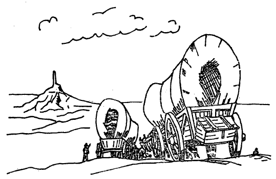
Occasionally during the 1830's, missionaries attached themselves to the fur caravans for protection on the long trek across the plains and mountains. These men included Jason Lee, Samuel Parker, and Dr. Marcus Whitman, who were the vanguard of settlement in Oregon. In 1842, Lt. John C. Fremont explored the Platte Valley-South Pass route west and wrote a report, widely circulated in the East, which praised the route's advantages as a way to Oregon. After Fremont's journey, the trail was no longer just the trappers' route but rapidly became the main highway for thousands of emigrants.
However, even before Fremont's trip, emigrants bound for the Pacific had ventured out over the plains. A small group of home seekers had gone overland to Oregon in 1841, followed by another small colony in 1842. In 1843, a thousand covered-wagon pioneers made their way to Oregon, and a two-decade massive migration west was begun. The pioneer band of Mormons, fleeing persecution in Illinois, were led by Brigham Young through the Platte Valley on their way to a new Zion in the valley of the Great Salt Lake in 1847. Like the earlier Oregon pioneers, they were followed by thousands in the years to come.
Two of the most numerous cross-country migrations occurred in 1849 and 1850,
The United States government established military posts along the trail during the 1840's to provide protection for the overland travelers. Fort Kearny was built in 1846 on the Missouri River, at the mouth of Table Creek (present-day Nebraska City). Soon the army discovered that this location was outside the main stream of overland travel, and in 1848 they moved Fort Kearny to a new location at the southern-most point of the big bend in the Platte. For more than two decades this fort provided assistance and protection to overland travelers, and was one of the most important centers along the trail. Part of the original military reservation is now Fort Kearny State Park. Farther west, the government purchased Fort Laramie from the American Fur Company in 1849, and turned it into a military establishment. An important stopping place for travelers, it was the army's principal field headquarters during the time of Indian troubles. It is now a National Historic Site.
The military posts in the West and the communities which developed in the Rocky Mountains required large quantities of goods from the east. Prior to the coming of the railroad, the only means of getting these supplies across the plains was by wagon. Subsequently, from the 1840's through the 1860's large overland freighting companies were developed. Freight arrived via the Missouri River steamboats at Independence, Atchison, Leavenworth, St. Joseph, Nebraska City, and Omaha, and then was transferred to heavy-duty wagons which traveled across the Platte Valley to the mountains. The freight wagons, drawn by as many as twelve oxen, carried loads varying from three to five tons at speeds of about two miles per hour - a far slower pace than our modern trucks which follow Interstate 80 today. Stage coaches filled the demand for "fast" service. The overland stage hauled passengers, express, and mail through the Platte Valley. The schedule, which at first took thirty-eight days from the Missouri River to California, later was shortened to nineteen days.
The Pony Express was the most dramatic of all the early attempts to improve communication between East and West. In operation for only a short time, from April 1860 through October 1861, its seemingly tireless young riders sped across the plains and mountains on a round-the-clock basis, in fair weather and foul, on a ten-day trip to the coast. The Express was a tremendously expensive venture, and it was impossible to carry enough mail in saddlebags to pay the vast outlay for horses, riders, and stations required to maintain the service. The operation almost brought financial ruin to the great freighting firm of Russell, Majors, and Waddell, who initiated the venture.
The transcontinental telegraph reached Omaha in 1860. In October, 1861, it was joined at Salt Lake City to a line being built from California. After the nation was spanned by telegraph, there was no longer a need for the Pony Express, and it was discontinued.
The final chapter in the great drama of overland migration through the Platte Valley was the construction of the transcontinental railroad. In 1865 the Union Pacific, which had been chartered by Congress in 1862, began building west from Omaha.
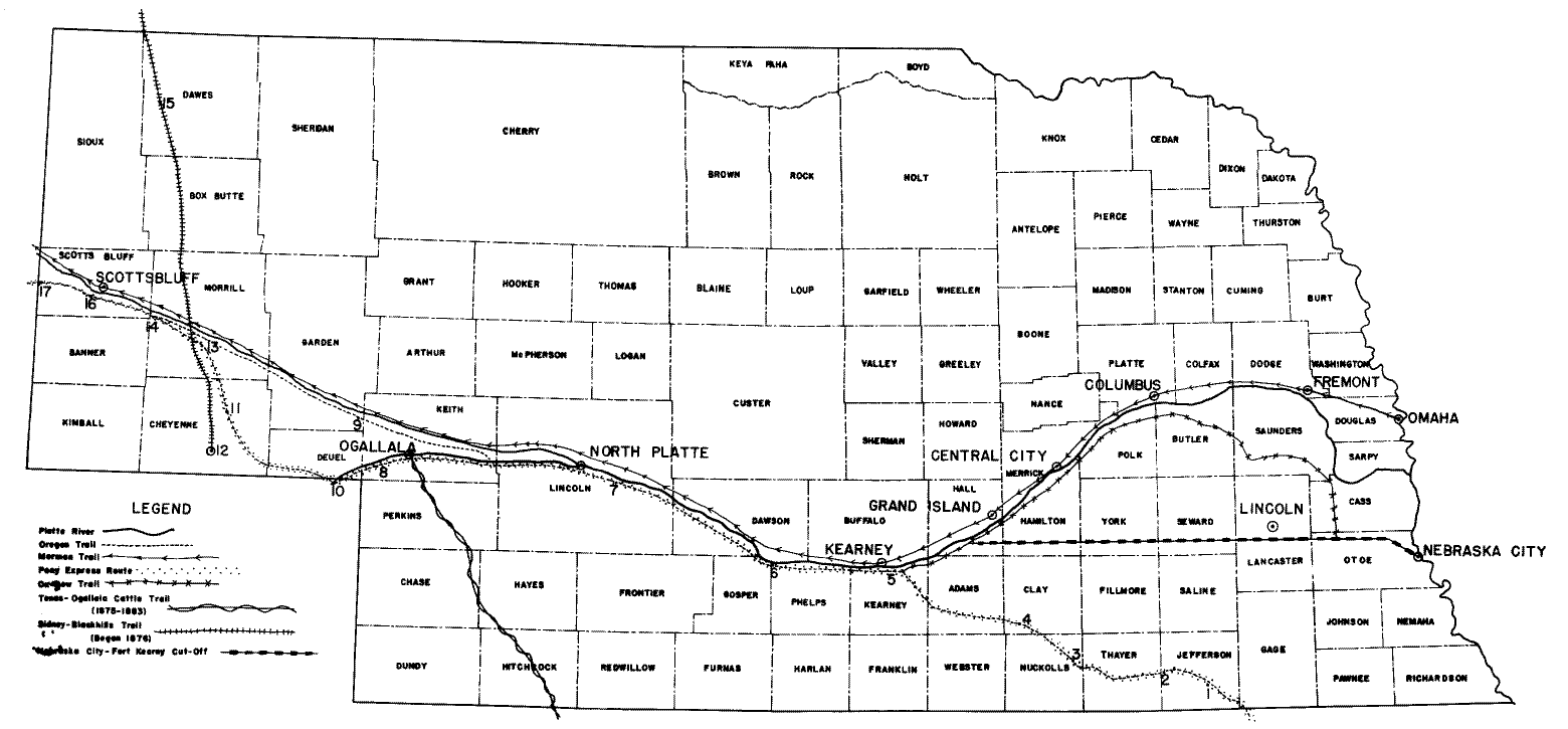
There were many alternate routes determined by the conditions of the trail, such as caused by the seasons and by the availability of grass. The South Platte was forded at numerous points, from as far east as the forks, which was near Fort McPherson, to as far west as Julesburg, Colorado. An important variation, particularly for the overland freight wagons, which often used Nebraska City as an eastern terminal, was the so-called "Nebraska City-Fort Kearny Cut-Off." This road, laid out and improved during the 1860's, ran almost due west from Nebraska City to the Platte River in Hall County. Prior to the opening of this road, freighters from Nebraska City had to use the more round-about Ox-Bow Trail, which went northwest from Nebraska City, crossed Salt Creek at Ashland, and joined the Platte near the present town of Cedar Bluffs.
Early travelers eagerly watched for the famous landmarks along the trail. Many of these sites are still visible today, and most of them have been appropriately marked. The best-known sites in Nebraska were Rock Creek Crossing in Jefferson County; Thirty-two Mile Creek in Adams County; Fort Kearny in Kearney County; Cottonwood Springs, Fort McPherson, Sioux Lookout, and O'Fallon's Bluff, all in Lincoln County; California Crossing in Keith County, and Ash Hollow in Garden County. In places along the trail, the old ruts are still visible, particularly at Scott's Bluff, Ash Hollow, and Fort McPherson.
Today Fort Kearny is a state historical park; Fort McPherson, a national cemetery; Scott's Bluff, a national monument; and Chimney Rock, a national historic site owned by the Nebraska State Historical Society. At Nebraska City you will find Arbor Lodge State Historical Park, and not far from the trail in Gage County is the Homestead National Monument of America, the site of the first homestead in the United States.
MORMON TRAIL. When Brigham Young, in the spring of 1847, led the pioneer band of Mormons west from Winter Quarters just north of Omaha, he decided to avoid the beaten path. Having been persecuted and driven from their former communities, the Mormons preferred to travel alone. Instead of following the Platte on the south side, their trail went from near Omaha to Fremont, and from there followed the Platte along its north bank across Nebraska. The most noted spot on this trail is the Mormon Cemetery. Located at Florence, now incorporated into Omaha, the Cemetery con-
tains the graves of many emigrants who died at Winter Quarters during their 1846-1847 sojourn, the victims of hunger, hardship, and disease.
OX-BOW TRAIL. Starting from Nebraska City, the Ox-Bow Trail, also called the Fort Kearny and Nebraska City Road, headed northwest and crossed Salt Creek near present-day Ashland, followed Wahoo Creek to a point near present-day Cedar Bluffs in Saunders County, and then continued westward on the south side of the Platte River. Eight miles east of Fort Kearny, the Ox-Bow Trail joined the old Oregon Trail from Independence, Missouri. It was 250 miles from Nebraska City to Fort Kearny by this "ox-bow" route.
Advantages of this route were the rock-bottom ford across Salt Creek at Ashland and the plentiful supply of water and wood. Also, those who followed the Platte felt more secure on a well-traveled route. However, the eastern Platte valley with its sand and its swampy areas was impassable when wet, and this, coupled with the longer roundabout route, caused Alexander Majors of the Russell, Majors, and Waddell Freighting Company to have surveyed from Nebraska City to Fort Kearny, a more direct route, which became known as the Nebraska City-Fort Kearny Cut-off.
NEBRASKA CITY-FORT KEARNY CUT-OFF. The trail began at Nebraska City and crossed Otoe, Lancaster, Seward, York, Hamilton, Adams, and Hall Counties before joining the Ox-Bow trail a few miles east of Fort Kearny, located on the Platte River in Kearney County.
Factors in locating this trail were both historical and geographical. Nebraska City was the location of Old Fort Kearny at Table Creek in present-day Otoe County. The freighting company of Russell, Majors, and Waddell had selected Nebraska City as their terminal, and had hauled freight over the Ox-Bow Trail, which crossed Salt Creek at present-day Ashland, and then followed the Platte River to Fort Kearny. As early as 1849, travelers' journals described several different routes from Nebraska City to Fort Kearny; however, all had one aim: to get their wagons into the broad Platte valley as soon as possible.
Hoping to find a shorter, easier route, Alexander Majors hired a surveyor in 1860. Geographically speaking, the exploring expedition found an ideal route. In addition to firm roadbeds and easy grades and stream crossings, there was a plentiful supply of wood and water. This more direct route, laid out in 1860 and 1861, became the main highway between Nebraska City and Fort Kearny, and cut the distance to Fort Kearny by 75 miles, as compared to the Ox-Bow Trail.
After 1860, most emigrants and freighters starting out from Nebraska City used the new cut- off. Later this trail became known as the "Steam Wagon Road," for it was from Nebraska City in 1862 that "General" Joseph R. Brown began his unsuccessful attempt to drive his steam wagon to Denver and the Colorado mines. A few miles west of Nebraska City the steam wagon broke down and Brown's plan eventually was abandoned.
Because the route was in nearly a straight line, the trail was often said to be an air-line route. Nebraska City newspapers, keeping the trail in the public eye through editorials and news articles, frequently called the cut-off the "Great Central Airline Route."
SIDNEY-BLACK HILLS TRAIL. The discovery of gold in the Black Hills (1874) precipitated a great rush to that region. Many goldseekers rode the Union Pacific westward to Sidney, and then struck off to the north through Cheyenne, Morrill, Box Butte, and Dawes counties to establish what became known as the Sidney-Black Hills Trail. It became a great freighting road, as vast quantities of freight were hauled from the railroad at Sidney via heavy-duty wagons to the mining camps of the Black Hills. Stage coaches also operated here, and on their return trips south frequently carried valuable cargoes of gold. Business was so great that H. T. Clarke of Bellevue built a bridge across the North Platte near the present city of Bridgeport. A masterpiece of solid construction, the bridge was a sixty-one span truss, two-thousand feet long, built of sturdy timbers. For twenty-five years it withstood heavy loads, ice, and floods. An important stop on this trail was near Fort Robinson.
NIOBRARA TRAIL This rather unknown trail, also called Sawyers Trail, was surveyed by James A. Sawyers and his party in 1865. Beginning at the mouth of the Niobrara River, the trail followed the river for about 300 miles, then headed northwest across the White River and into present day Wyoming. Continuing northwest, it eventually joined the Bozeman Trail and terminated at Virginia City in presesnt (sic) day Montana, over 1,000 miles from the Niobrara.
The Niobrara Trail did not have extensive use because it was too far north of the main emigration route. It was situated in a more arid country than the Oregon Trail and the government did not fortify the route. However, the Niobrara Trail later became an alternate route to the Black Hills, and was joined from the south by a trail coming up the Elkhorn Valley.
TEXAS-OGALLALA TRAIL. Cattle herds, rather than people, made this trail famous in Nebraska history. From 1875 to 1884, Ogallala - Nebraska's Cowboy Capital was the terminal of cattle drives north from Texas. From June to August, the sleepy tank-town on the Union Pacific hummed with activity. Here the cattle herds were sold to Nebraska and Wyoming ranchers for winter pasturing. A year or two later these same herds were rounded up and shipped east for marketing. When the route north became settled by homesteaders, trail drives were pushed further west and finally were discontinued. The trail entered Nebraska in Hitchcock County, crossed through the corners of Hayes and Chase counties, divided Perkins County, and terminated at Ogallala.
Ackerman, Louise M. (ed.) Historical
Markers in Nebraska, National Daughters of the American
Revolution
in
Nebraska, 1951. (Data on historical markers in Nebraska arranged
by counties.)
Hunt, N. Jane (ed.) Brevet's Nebraska Historical Markers and Sites. Brevet Press, Sioux Falls, 1974.
Condra, George E., James C. Olson, and
Royce Knapp. The Nebraska Story 1951. (Nebraska
history,
geography,
and government.)
Dick, Everett. Conquering the Great American Desert. NSHS Pub. 27.
Federal Writer's Project. Nebraska: A
Guide to the Cornhusker State. 1939.
(Nebraska
number of the American Guide Series.)
Holmes, Louis A. Fort McPherson, Nebraska. 1951. (illustrated.)
Lass, William E. From the Missouri to
the Great Salt Lake. 1972, NSHS Publicatlon 26, Lincoln.
(An
account of overland freighting.)
Mattes, Merrill J. The Great Platte River Road. 1969, NSHS Pub. 25, Lincoln.
Nicoll, Bruce H. and Keller, Ken R. Know Nebraska. 1951. (Illustrated.)
Olson, James C. History of
Nebraska. Nebraska Press, Lincoln, 1966. (Relates the trails
to the overall
history
of the state.)
Root, Frank A. and William E. Connelley.
The Overland Stage to California. 1950. (The history of the
Pony
Express
and stage lines following the trail across Nebraska.)
Sheldon, A. E. Manuscript, Nebraska State Historical Society Library.
Sheldon, A. E. Nebraska, Old and New.
Steward, George R. The California Trail, 1962. (Overland trails in American history.)
MAGAZINES
Nebraska History. Nebraska State
Historical Society, Box 82554, Lincoln, Nebraska, 68501. (A
quarterly
journal devoted to
the history of Nebraska.) Back issues if not available in local
library may be
purchased
at $3.00 per copy.
Martin, Charles W. "A Round Trip to the Montana Mines: The 1866 Travel Journal of Gordon P. Lester." Vol. 46, No. 4, 1965. (Stage travel across Nebraska was uncomfortable as well as unreliable.)
Mattes, Merrill J. "Chimney Rock on the Oregon Trail," Vol. 36, No. 1, 1955. (The history of Chimney Rock as recorded in pioneer diaries and by early artists.)
Mattes and Paul Henderson. "The Pony Express Across Nebraska from St. Joseph to Fort Laramie." Vol. 41, No. 2, 1960. (The exact location of each known station and a brief history.)
Mattison, Ray H. "The Military Frontier on the Upper Missouri." Vol. 37, No. 3, 1956. (Sketches of all the Nebraska forts and their place in history.)
McCann, Lloyd E. "The Grattan Massacre (1854)." Vol. 37, No. 1, 1956. (A battle developing out of emigrant problems.)
Mortensen, A. R. "Mormons, Nebraska and the Way West," Vol. 46, No. 4. 1965.
Nebraskaland. Nebraska Game and
Parks Commission, 2200 N. 33rd St., Lincoln, Nebraska.
(A
monthly magazine devoted to Nebraska out-of-doors.)
|
KEY FOR NUMBERED SITES: |
|
|
1 Rock Creek Station |
9. Ash Hollow |
|
2. Big Sandy Station |
10. Julesburg, Colorado |
|
3. Little Blue Station |
11. 30 - Mile Ridge Station |
|
4. Liberty Farm Station |
12. Fort Sidney |
|
5. Fort Kearny |
13. Mud Springs Station |
|
6. Plum Creek Station |
14. Chimney Rock Station |
|
7. Fort McPherson |
15. Fort Robinson |
|
8. Beauvais Station |
16. Scotts Bluff |
|
17. Horse Creek Station |
|
