NEGenWeb Project
On-Line Library
NEBRASKA HISTORY MAGAZINE |
243 |
to allow him to put the American flag up. This is one of their legends handed down, for here the Indian had to show to white man how he kindled fire and how to obtain food by killing game and how they cut the meat with the flint-things provided them by the "Great Spirit." They are glad that their friends, the white people, are trying to preserve their old home. If they were able, how glad I would be to try and help the Society in collecting money from these people, but may you people do all you can, and God will be with you and bless you.
Your friend, JAMES R. MURIE.
PIKE'S ROUTE TO THE PAWNEES
It would be easier to follow his route through Kansas, from his journal and map, if he had followed prominent streams. Upon entering what is now Kansas and reaching the Neosho valley near the present lola, the most direct and easy route to the Pawnee Republic would have been to have followed that valley along by the present Burlington, Emporia, Council Grove to its very head and over the narrow divide to Junction City. From there the Republican valley was also an easy and plain route northwest and would have led him directly to his goal. Those two valleys, the Neosho and the Republican, would have furnished a level bottom route all the way, with the single exception of the twenty-mile divide from the head of one to the mouth of the other, and with excellent camping places at any time. Living in the Neosho valley most of my life, I have often wondered why Pike did not follow those streams, thus saving about one-third in distance and with one-half the exertion.
But, instead, he kept away from the main valleys, crossing narrow uplands and rocky divides between numerous small creeks, traversing the two sides of a right-angled triangle, when following the hypotenuse would have sufficed. He was either misinformed or his Indian guides purposely went the longer way, which was about as rough and indirect as he could have selected.
In some features Pike's map is very faulty, especially in the direction and termination of many streams. For instance, he has the Saline and Solomon rivers empty into the Republican. Fortunately, his journal and map tell of his daily camping places and his journal is faithful in giving the distances daily traveled. To one familiar with the topography of the country he covered in Kansas, it is not so difficult to determine his course and his camping places.
| 244 | NEBRASKA HISTORY MAGAZINE |
I am fairly well acquainted with the geography and topography of that part of the present state of Kansas traversed by the Pike party, and especially from where he crossed the Neosho valley to the Pawnee Republic. Some of it I followed on horseback before the days of wire fences and section-line roads. That part he covered during the last three or four days of his trip has been examined this fall. Using his journal of descriptions, dates and distances and starting at some known place or river he reached and crossed, say in Chase, Marion, Saline counties or elsewhere, and it is a mathematical certainty that on the 25th day of September, 1806, he could not have been further north than our well-marked monument on the Pawnee Indian Republic site, eight miles north and about two miles east of the town of Courtland, Republic county, Kansas.
That is the day he records as having arrived at the Pawnee capital; and at his average rate of travel, It would have required three or four more days longer than September 25 to have reached the Nebraska site--even if it had existed at that time. It settles the matter beyond any question of doubt, unless he jumped or was carried by some aeroplane.
He has passed into Saline county and camps on the west branch of Gypsum creek, some six miles east of Bridgeport.
September 17.--"Marched early and struck the main southeast (Smoky Hill) branch of the Kansas river at nine o'clock. It appeared to be 25 or 30 yards wide and is navigable in flood seasons. We passed it six miles to breakfast. Game getting scarce, our provisions began to run low. Marched at about two o'clock and encamped at sundown on a large branch (Mulberry creek). Killed one buffalo. Distance 21 miles."
Their crossing the Smoky Hill at nine in the morning was near Bridgeport and their camping place that night was two or three miles west of Salina. From here his route is almost directly north.
September 18.--Marched at the usual hour and at twelve halted at a large branch (Saline River) of Kansas (Smoky Hill), which was strongly impregnated with salt. This day we expected the people of the Pawnee village to meet us. We marched again at four o'clock, our route being over a continuous series of hills and hollows.
'We were till eight at night before we arrived at a small dry branch. It was nearly ten before we found any water. Commenced raining a little before day. Distance 25 miles."
This was a hard day's travel and the party were going over that well-known broken, hilly and rocky country several miles
NEBRASKA HISTORY MAGAZINE |
245 |
southwest from Minneapolis. They crossed the Saline near Culver, and they had a hard time finding a camping place that night at ten o'clock.
Here they camped for three days, as they struck a very rainy spell, the fall equinox, and had a dull experience.
September 19.--"It rained all day; we secured our baggage and pitched our tents. Employed ourselves reading the Bible and Pope's Essays, and In pricking on our arms, with India ink, some characters which will frequently remind us of our forlorn and dreary situation, as well as the happiest days of our life.
"In the rear of the camp was a hill on which there was a large rock, where the Indians kept continual sentinel, as I imagine, to apprise them of the approach of any party, friend or foe, as well as to see if they could discover any game on the prairies."
September 20 Pike tells of another rainy day in camp. He says:
"The Osage sentinel discovered a buffalo on the prairies; upon which we dispatched a hunter on horseback in pursuit; also some hunters on foot; before night they killed three, some of the best of which we brought in and jerked and dried by the fire. The detention of the doctor and our Pawnee ambassadors begin to be a serious matter."
It would be interesting to know and mark the exact spot of this rained-in camp where they were delayed for about three days. It was on some small watercourse in that barren region about midway between Culver and Ada, in the southwest part of Ottawa county. The "Sentinel Hill," with the large rock on top, I think has been located. It must have been a few miles south of Salt or Covert creek, which they crossed the next morning at eleven o'clock, September 21, when they resumed their journey.
Sunday, September 21.--"We marched at eight o'clock, and at eleven passed a large creek remarkably salt. (Salt or Covert creek, which flows into the Solomon river a few miles south of Minneapolis, in Ottawa county.) Stopped on a fresh branch of the salt creek. Our interpreter having killed an elk, we sent out for some meat and this detained us so late we concluded it best to encamp where we were, in preference to running the risk of finding no water. Distance ten miles."
They were delayed this day waiting for meat, and their camp was not far north of their crossing of Salt creek, and at the first place they found water.
September 22.--"We did not march till eight o'clock, owing to the indisposition of Lieutenant Wilkinson. Stopped at eleven
| 246 | NEBRASKA HISTORY MAGAZINE |
o'clock to dine. Marched again at three, and continued our route twelve miles to first branch of Republican fork. (There is some error here, as their total distance that day was only eleven miles. Possibly the twelve miles should read two miles.) Met a Pawnee hunter, who informed me that the chief had left the village the day after the doctor arrived, with 50 or 60 horses and many people, and had taken his course to the north of our route--consequently we had missed each other. He also informed us that the Teaus (Ieatans or Comanches) had recently killed six Pawnees, and Kansas had stolen some horses, and a party of 300 Spaniards had lately been as far as the Sabine; for what purpose unknown. Distance eleven miles.)"
On account of Lieutenant Wilkinson's illness, they made only eleven or twelve miles. This brought them to a point a few miles west of Delphos and quite near the Solomon river, which he calls the first branch of the Republican fork. Pike thought that the Solomon was a branch of the Republican. He had never been at its mouth.
His reference to continuing "our route twelve miles," in the afternoon is a little obscure, but may be because of the error above mentioned, or it may be a statement regarding the entire day's travel--which is only one miles in excess of that mentioned at the close of his daily journal "Distance 11 miles." He was now seven or eight miles south of where he forded the Solomon the next morning. The Pawnee Republic is about forty-seven miles due north, and this he will cover in the next three days by marching 21, 18 and 12 miles respectively.
September 23.--"Marched early and passed a large fork of the Kansas, which I suppose to be one generally called Solomons. (Solomon river.) One of our horses fell into the water and wet his load. Halted at ten o'clock on a branch of this fork (Fisher creek, which runs into the Solomon near Glasco). Marched at half past one o'clock and encamped at sundown on a stream (White's creek or Wolf creek), where we had great difficulty to find water. Overtaken by a Pawnee, who encamped with us. He offered his horse for our use. Distance 21 miles."
This is the day he crossed the Solomon river in the middle of the forenoon; he states so himself, and his map shows it. Thus this becomes another fixed and known geographical point and a check to prove where he went, and just how far he went, on this date. The ancient Indian name of the Solomon river was Nepaholla, a Kanza Indian term meaning "water on top of hill." This came from the peculiar mineral spring near Cawker City, Mitchell county, a large deep pool of water on the top of a hill. It is now known as Waconda or Great Spirit spring. Just when Solomon's fork was named is uncertain, but it seems
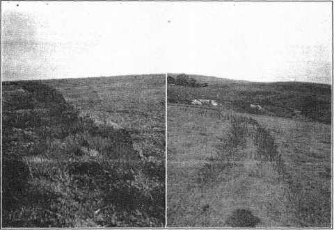
Two views of Old Pawnee Trail travelled by Spanish troops and by Lieut. Pike in 1806.
About 1 mile southeast of Pawnee burial bill. Photo 1925.
NEBRASKA HISTORY MAGAZINE |
247 |
that it was prior to Pike's visit. His direction and distances show that his crossing was near the present Glasco, in Cloud county. There was an old ford there, and many years ago an ancient flintlock pistol and other trinkets were found--possibly lost when that pack horse, with its load, fell Into the river. This caused their halt at ten o'clock, or till one o'clock in the afternoon. He was going north across the divide between the Solomon and the Republican, and his camp must have been at the head of some branch of the Republican, probably White's creek, which accounts for his difficulty in finding water. His camp was about twelve miles north of Glasco and from four to six miles south of the present Jamestown, In Cloud county. He is about twenty-seven miles directly south of the Pawnee Republic, which from the record he makes in two days by going thirty miles--eighteen miles on the 24th and twelve miles on the 25th, the day he arrived. This comes out correctly, as he would lose two or three miles in his usual winding course by following uplands.
September 24.--Pike says: "Could not find our horses till late, when we marched. Before noon met Frank, who had accompanied Doctor Robinson to the village, and the three Pawnees, who informed me that the chief and his party had arrived at the village yesterday, and had sent them out to search for us. Before three o'clock we were found by several Pawnees; one of these wore a scarlet coat, with small medal of General Washington, and a Spanish medal also.
"We camped at sunset on a middle-sized branch, and were joined by several Pawnees in the evening, who brought us buffalo meat. Here we saw some mules, horses, bridles and blankets, which they obtained from the Spaniards. Few only had breech cloths, most being wrapped in buffalo robes; otherwise quite naked. Distance 18 miles."
We have now brought the Pike party to his last camping place before reaching the village--still twelve miles further on to the north. The directions and distances prove that this camp was about three miles southwest from the present town of Courtland, in Republic county, probably on the stream known as Short creek.
From this point it was a plain and natural highway north and south and on the line of the Pawnee trail, so well known and still pointed out by those like E. D. Haney, who lived in that region over fifty years ago before the days of the plow and the wire fence. A short time ago, with Mr. Haney, we were taken over about forty miles of the route of that natural highway, over which Pike traveled his last two days. Some of that old Pawnee trail is still visible by its sodded ruts and ridges in
| 248 | NEBRASKA HISTORY MAGAZINE |
uncultivated lands south of Courtland, and down to and beyond the "Salt Marshes." This is the mentioned road where Pike picked up the trail of the Malgares Spanish troops, who had visited the Pawnees just prior to his coming. It led right to the Pawnee village, and is an important item in proving just where the village was located.
We now come to an account of his last day's journey of twelve miles before reaching the village, and in which he gives a graphic description of his arrival and the alarming reception upon the part of the Pawnees. They seemed determined to impress him with their numbers and importance in comparison with the apparent insignificance of his little party of explorers.
September 25.--"We marched at a good hour, and in about eight miles struck a very large road, on which the Spanish troops had returned, and on which we could yet discover the grass beaten down in the direction which they went.
"When we arrived within about three miles of the village we were requested to remain, as the ceremony of receiving the Osage into the town was to be performed here. There was a small circular spot, clear of grass, before which the Osage sat down. We were a small distance in advance of the Indians. The Pawnees then advanced to within a mile of us, halted, divided into two troops, and came on each flank at full charge, making all the gestures and performing the maneuvers of a real war charge. They then circled us around, and the chief advanced in the center and gave us his hand. His name was Caracterish. He was accompanied by his two sons and a chief by the name of Iskatappe. The Osages were still seated, but Belle Oiseau then rose and came forward with a pipe and presented it to the chief, who took a whiff or two from it. We then proceeded; the chief, Lieutenant Wilkinson and myself in front, my sergeant, on a white horse, next, with the colors, then our horses and baggage, escorted by our men, with the Pawnees on each side, running races, etc. When we arrived on the hill over the town we were again halted, and the Osages seated in a row; when each Pawnee who intended so to do presented them with a horse, and gave a pipe to smoke to the Osage to whom he had made the present. In this manner were eight horses given. Lieutenant Wilkinson then proceeded with the party to the river above the town and encamped. As the chief had invited us to his lodge to eat, we thought it proper for one to go. At the lodge he gave me many particulars, which were interesting to us, relative to the late visit of the Spaniards.
"I went up to our camp in the evening, having a young Pawnee with me loaded with corn for my men. Distance, twelve miles. (This distance refers to mileage of that day.)
|
© 2004 for the NEGenWeb Project by Ted & Carole Miller |
||