NEBRASKA HISTORY MAGAZINE |
249 |
NEGenWeb Project
On-Line Library
NEBRASKA HISTORY MAGAZINE |
249 |
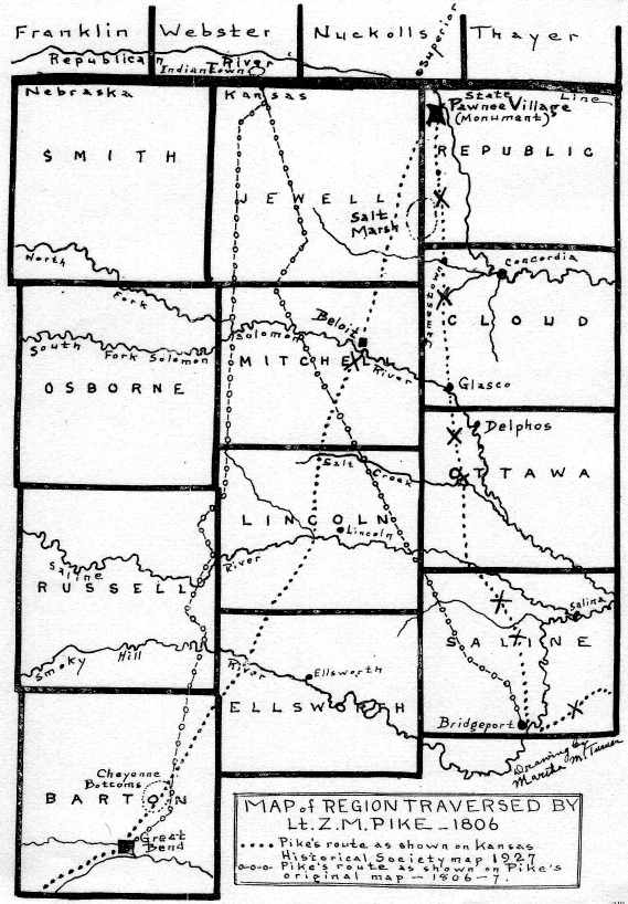
SUMMARY OF CAMPS AND DISTANCES FROM SOUTH COTTONWOOD FORD
We submit this summary of the camps and daily distances Pike covered from where he crossed the South fork of the Cottonwood, at a point between Bazaar and Matfield Green, in Chase county, and on to the Pawnee village.
This checks up his course from present-day geographical points and proves that he could not have arrived at any other point by September 25, than the Pawnee Republic site in Republic county, Kansas.
Sept., 1806 |
Miles. |
|
12. |
South Cottonwood ford to camp east of Florence |
17 |
13. |
To camp on Clear creek, north of Marion |
9 |
14. |
To Cottonwood crossing, near Durham |
21 |
15. |
To camp near Carlton, Dickinson county |
18 |
16. |
To Gypsum creek camp, six miles east of Bridgeport |
13 |
17. |
To Mulberry creek camp, three miles west of Sauna |
21 |
18. |
To "Sentinel Hill" camp on dry branch of Salt or |
|
|
Covert creek, in southwest Ottawa county, where |
||
|
they were rained in for two days |
25 |
|
19. |
In camp, "a rainy day," "reading Bible and Pope's Essays" |
|
20. |
Another rainy day in camp, drying buffalo jerk by the fire |
|
21. |
To camp just north of Salt or Covert creek |
10 |
22. |
To camp west of Delphos, about seven miles south |
|
|
of Glasco, and near the Solomon, which they cross |
||
|
the next morning |
11 |
|
23. |
To camp head of White's creek, south of Jamestown, |
|
|
Cloud county |
21 |
|
24. |
To Short creek, southwest of Courtland, Republic county |
18 |
25. |
To the Pawnee Republic, where the monument now stands |
12 |
|
|
|
How could Pike have reached a place up in Nebraska, three or four daps' (sic) travel beyond the Kansas site, within the date September 25, the date he reached the Pawnee village?
These dates and distances are taken from Pike's journal, and where he calls streams by the old names of that day, they are harmonized with present-day geography, as we understand it. This is not so difficult if we compare his descriptions and map with the topography of country traversed and our maps of the present time.
| 250 | NEBRASKA HISTORY MAGAZINE |
The site of Pawnee Republic village is 66 miles west and 117 miles north of his crossing of the South fork of the Cottonwood, from which we more particularly describe his journey. This totals 183 miles, and Pike reached his goal by traveling just 186 miles in the twelve days, or an average of fifteen and one-half miles per day. Could he have gone on an air line he could have covered it in 150 miles by going exactly northwest. But the course he followed was almost west and then north, going the two sides of a triangle. And yet, with his known windings, the distance he traveled was almost exactly the same one would cover to-day, over section lines, between the South fork of the Cottonwood and the village.
We must not wonder that he marched farther than necessary. He was the first American to explore and cross the Kansas region, which was then a barren waste, and he had to feel, almost grope, his way through dangers and long distances. He was truly a "pathfinder."
"When I was once on the summit of the hill which overlooks the village, I felt my mind relieved from a heavy burden; yet all the evil I wished the Pawnees was that I might be the instrument, in the hands of the government, to open their eyes and ears with a strong hand, to convince them of our power.
'Our party now consisted of two officers, one doctor, eighteen soldiers, one interpreter, three Osage men, and one woman, making twenty-five warriors. We marched out and encamped on a small branch (probably near their camping place on the night of September 24), distant seven miles, on the same route we came in. Rain in the night.
COUES' ERROR IN EDITING PIKE'S JOURNAL
In his work of editing Pike's Journal, in two volumes, 1895, Dr. Elliot Coues follows him into Nebraska in reaching the Pawnee Indian Republic. While Doctor Coues' copious notes concerning Pike's travels are, for the most part, useful and interesting, they are very misleading upon the matter of where that Indian Republic was, and very incorrect as to the camping places and distances he traveled the last three or four days of his journey. He jumps Pike forty or fifty miles further north than his journal says he reached. Those who hold to the Guide Rock, Neb., site as the correct place have never found those three or four extra days it would have taken him to have reached the Nebraska site--simply because the record of the distances is against them. In fact Pike's record of dates of his daily travel, known streams crossed and his camping places, prove to a mathematical certainty that he never reached the Nebraska state
|
© 2004 for the NEGenWeb Project by Ted & Carole Miller |
||